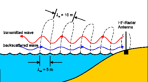
HF radar systems use either direction-finding (DF) (Coastal Ocean Dynamics Application Radar SeaSonde: SS) or beam-forming techniques (BF) (WEllen RAdar: WERA) to acquire radial currents from the Bragg peaks in the Doppler spectra. For both DF and BF techniques, the approach utilizes backscatter from surface waves of one-half the radar wavelength (i.e. Bragg wave) to form a Doppler Spectrum (Crombie 1955; Stewart and Joy 1974). First-order returns in this spectrum are associated with the frequency shift from the Bragg frequency that are proportional to the radial surface current of the dominant peak in the spectrum for either receding or advancing waves toward the radar site. To map the two-dimensional surface current vector, each experimental domain requires at least two radar sites. The ratio of the first-order Bragg peaks of the advancing and receding waves is related to the wind direction, and with two or more stations the ambiguity in resolving the wind direction is removed. Surface wave signatures, however, are derived from the second-order returns for both the significant wave heights (Hs) and directional wave spectrum (WERA only) following Wyatt et al. (2003). The domain over which surface waves can be mapped is a function of the noise floor that increases with distance offshore. Waves can be mapped over 55% to 65% of the radar domain from the first-order returns.
The University of Miami chose the WERA HF radar system for its functionality. The WERA system transmits a frequency modulated continuous wave (FMCW) chirp that avoids the 3 km blind range in front of the radar, which is an issue with pulsed systems (Gurgel et al., 1999; Essen et al., 2000). The temporal resolution of WERA is a function of the chirp characteristics (0.26 s) and can be as little as a few minutes up to hourly intervals. For transmission frequencies of 8 and 16 MHz, Bragg wavelengths are 18.7 and 9.35 m, respectively. The four-element transmitter is arranged to encompass about a 120° swath. WERA has the flexibility to be configured into a DF array (such as SS) where four antennae may be set up in a square where the distance between elements is proportional to the Bragg wavelength. A linear array is set up consisting of 4n elements (n =2,3,4....) using BF techniques. This gives the WERA system flexibility for deployments where the real estate may be limited. Generally, the more antennae, the better the resolution of the current direction (Teague et al., 2001) and for accurate surface wave directional spectra, 16-element arrays are preferred (Wyatt et al., 2003). While higher spatial resolution requires considerable bandwidth (~200 KHz), temporal sampling can be from a few minutes to hours because the system is FMCW. Cable calibrations must be checked periodically to monitor any variations in signal amplitudes and phases. One of the new features that have been recently installed is the Radio Frequency Interference (RFI) reduction approach (K.W. Gurgel, 2006, personal communication). This approach allows a specific frequency band to be scanned to adjust signal transmission to a frequency where there is minimal noise within the band.
There is the tradeoff between transmission frequency and bandwidth, which determine range and resolution, respectively. The SS system uses a whip transmit (Tx) antennae and one crossed-loop/monopole receiver (Rx) antennae. The least squares fitting procedure of Lipa and Barrick (1983) has been replaced by MUSIC algorithm which allows for more than one azimuthal direction of the surface current (DePaolo and Terrill 2007). An important consideration for SS systems is the measurement of the receiver beam pattern (Kohut and Glenn, 2003; Emery et al., 2004). Especially for deployment sites in developed areas, the measured beam pattern can depart significantly from the ideal beam pattern and failure to use the correct beam pattern in processing can significantly impact the accuracy of the current estimates. At lower transmitting frequencies in the 5 to 10 MHz range for longer-range transmissions (Bragg wavelengths of 30 and 15 m, respectively), available bandwidth tends to be limited by the FCC compared to Very High Frequencies (VHF: >50 MHz) where bandwidth is available to sample high spatial resolution (< kilometer). The region of the shelf where standard processing can produce reliable velocity estimates is limited to water depths where the surface waves producing the Bragg scattering can be considered deep-water waves. This constraint limits the inshore coverage region on shallow shelves and is a concern for the longer range (lower frequency) systems used. All SS systems are omni-directional and use a pulsed swept frequency continuous wave with pulse widths of 100-200 ms in normal mode compared to 1000-2000 ms in low-resolution mode. For the long-range systems there is typically an hourly output that is an updated, three-hour running average.
Long-term Monitoring of East Florida Shelf
The Florida Current (FC) in the Straits of Florida (SOF) is an oceanic regime characterized by large horizontal current shears, relative vorticities that are up to five times the local Coriolis parameter and strong topographical gradients (Peters et al., 2002). The SOF is a narrow channel between the southern Florida peninsula and Cuba. Given its proximity to major population centers along the eastern seaboard of the United States, the circulation in this region has been extensively studied. Notwithstanding, a common thread in all of these studies is the predominance of the FC, which connects the Loop Current (LC) in the Gulf of Mexico (GOM) to the Gulf Stream (GS) in the South Atlantic Bight (SAB).
In recent years, the focus has been targeted at understanding the transient FC features such as eddies and intrusions owing to the important role they play in the biological realm and the health of coral reefs. Lee et al. (1995) discussed cyclonic frontal eddies near Dry Tortugas that periodically move into the Straits and translate eastwards along the Keys. Fratantoni et al. (1998) used satellite imagery to conclude that these Tortugas gyres are the downstream expression of LC frontal eddies. As these ”spin-off” eddies propagate through the southern extent of the SOF they can produce large southward displacements or meanders of the eastward flowing FC axis (Lee et al., 1995; Fratantoni et al., 1998; Hamilton et al., 2004). These eddies are advected in the southern SOF at approximately 5 to 15 km d-1 and the coincident meanders in the FC continue to travel downstream in phase with the eddies (Lee et al., 1992; Fratantoni et al., 1998).
Caption: EFS radar coverage.
In June 2004, two WERA stations were deployed along the EFS between Key Biscayne, FL and Key Largo, FL. During this period of operation, an ADCP was deployed within the radar footprint from September 2004 to June 2005 (Gurgel et al., 1999a; Shay et al., 2007). The EFS radar network consists of two WERAs that provide near-real time surface currents to SEA-COOS and the internet (Gurgel et al., 1999; Shay et al., 2007, 2008).
Currently in their fifth continuous year of operation, radars are located at Crandon Park on Key Biscayne (25°42.84’N, 80°9.06’W), Key Largo (25°14.46’N, 80°18.48’W), Virginia Key (25°44.47'N, 80°8.78'W) and Dania Beach(26°5.0N ,80°7.0'W), Florida. Each site contains four transmitting antennae (Tx) and 16 receiving antennae (Rx). Figure 1 shows approximate radar coverage for this WERA system. The Virginia Key radar operates at a frequency of 12 MHz while the other three radars operate at a frequency of 16.045 MHz. The radar system maps surface currents every 20 minutes over approximately X cells with a cell resolution of 1.2 km. Receiver and transmitter cables are calibrated to monitor any variations in signal amplitudes and phases.